


Williams Twp. Voting District, Aitkin County, Minnesota
About
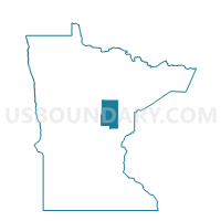
Outline

Summary
| Unique Area Identifier | 600897 |
| Name | Williams Twp. Voting District |
| County | Aitkin County |
| State | Minnesota |
| Area (square miles) | 35.86 |
| Land Area (square miles) | 35.83 |
| Water Area (square miles) | 0.03 |
| % of Land Area | 99.92 |
| % of Water Area | 0.08 |
| Latitude of the Internal Point | 46.20110150 |
| Longtitude of the Internal Point | -93.24379640 |
Maps


Graphs
Select a template below for downloading or customizing gragh for Williams Twp. Voting District, Aitkin County, Minnesota


Neighbors
Neighoring Voting District (by Name) Neighboring Voting District on the Map
- Ford Twp. Voting District, Kanabec County, MN
- Hay Brook Twp. Voting District, Kanabec County, MN
- Idun Twp. Voting District, Aitkin County, MN
- Kroschel Twp. Voting District, Kanabec County, MN
- McGrath Voting District, Aitkin County, MN
- Millward Twp. Voting District, Aitkin County, MN
- Pliny Twp. Voting District, Aitkin County, MN
- Seavey Twp. Voting District, Aitkin County, MN
- Wagner Twp. Voting District, Aitkin County, MN
Top 10 Neighboring County Subdivision (by Population) Neighboring County Subdivision on the Map
- Wagner township, Aitkin County, MN (332)
- Idun township, Aitkin County, MN (259)
- Hay Brook township, Kanabec County, MN (246)
- Kroschel township, Kanabec County, MN (216)
- Ford township, Kanabec County, MN (195)
- Williams township, Aitkin County, MN (144)
- Pliny township, Aitkin County, MN (109)
- McGrath city, Aitkin County, MN (80)
- Millward township, Aitkin County, MN (72)
- Seavey township, Aitkin County, MN (61)
Top 10 Neighboring Place (by Population) Neighboring Place on the Map
Top 10 Neighboring Unified School District (by Population) Neighboring Unified School District on the Map
- Mora Public School District, MN (10,911)
- East Central School District, MN (7,084)
- Hinckley-Finlayson School District, MN (7,083)
- McGregor Public School District, MN (4,250)
- Isle Public School District, MN (3,267)
Top 10 Neighboring State Legislative District Lower Chamber (by Population) Neighboring State Legislative District Lower Chamber on the Map
Top 10 Neighboring State Legislative District Upper Chamber (by Population) Neighboring State Legislative District Upper Chamber on the Map
Top 10 Neighboring 111th Congressional District (by Population) Neighboring 111th Congressional District on the Map
Top 10 Neighboring Census Tract (by Population) Neighboring Census Tract on the Map
- Census Tract 4801, Kanabec County, MN (3,578)
- Census Tract 7704, Aitkin County, MN (3,052)
- Census Tract 7905.01, Aitkin County, MN (1,957)